PinchEmTight Rock
| Route 66 | Cities | Beaches |
|
PinchEmTight Rock |
|
| Auxier Ridge | Martins Fork | Grays Arch | Rush Creek | Pinchemtight | KoomerRidge | ChimneyTopCreek | ParchedCornCreek | SwiftCampCreek |
| IndianStaircase | Castle Arch | Osborne Bend | Raven Rock | Red Byrd Arch | Indian Creek | Revenuers Ridge | Copperas Falls |
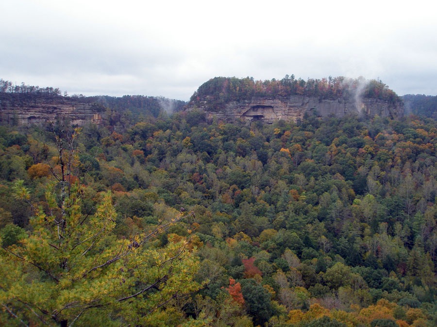
| PinchemTight Trail is the easiest trail in the Gorge but leads to one of its most spectacular overlooks. It's also a frequent connector trail used along with Rush Creek Trail, Buck Trail or Rough Trail to create various loops or through hikes to other destinations. And it's the most commonly used trail to reach Hanson's Point, the Gorge's favorite back country campsite. PinchemTight Trail is almost perfectly level the whole way. It rises or drops only a few feet as PinchemTight Ridge undulates slightly over its length. You have to be able to hike four miles to do this trail. It's two miles out and another two back. Almost everyone takes a very long lunch or snack break on PinchemTight Rock (photo, right) to enjoy the views and bask in the Sun. And many people spend the night there, pitching their tent or stringing their hammock at Hanson's Point, 100 yards back from the actual overlook, so they can see or photograph the sunset and sunrise at PinchemTight Rock. | 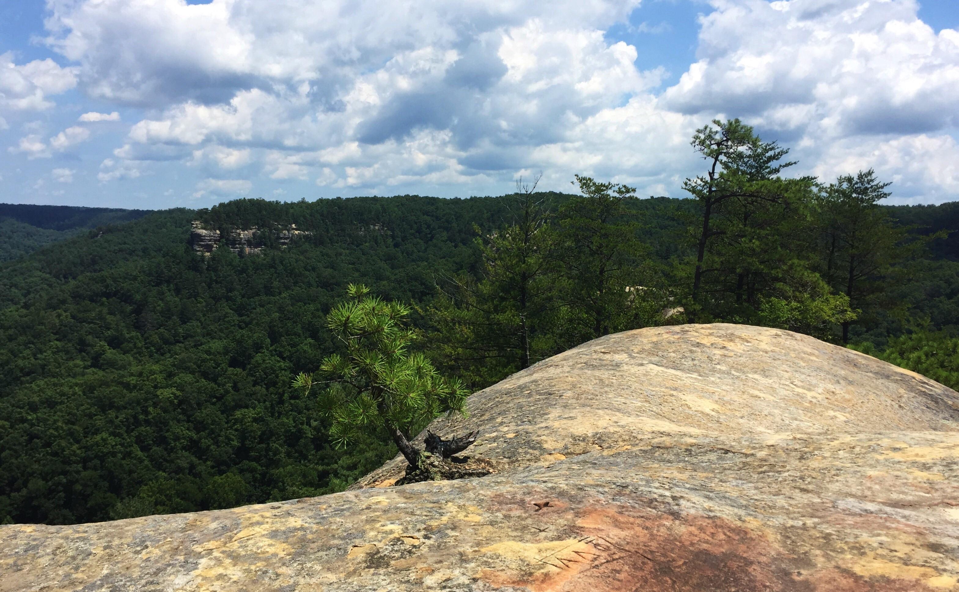 |
| pic of trail showing the narrow ridge | The ideal time of year to make this hike is October. Even though you're hiking high on a narrow ridge with mostly pine trees, you'll be looking both left and right at valleys and plateaus filled with Oak, Maple, Ash, Beech, Birch, Tulip Poplar and other deciduous trees whose leaves are yellow, red and orange. Views from PinchEmTight Rock are filled with color. The heat and humidity are gone and you can fill your lungs with crisp cool air. The Spring months are OK, but because of the high, dry, sandy ridge, there are not the wildflowers you could find down in the valleys. Summer can be a sauna, with blazing heat and dripping humidity. In Winter, the wind whips across the ridge, plunging the ambient temperatures down to the 30s or 20s. High on the ridge, there are no waterfalls to admire. Once you pass the two side trail intersections, the ridge will narrow to 6-12 feet until you reach Rough Trail, when it widens out again. |
There is widespread confusion about the names at the end of this trail. The large rock which provides the panoramic views is PinchEmTight Rock. At its base, several hundred feet down, it forms the southern wall of PinchEmTight Gap, the narrow passageway early White settlers had to squeeze through when travelling from Chimney Top Valley over to Rush Creek Valley. This formation and the Gap have been called PinchEmTight since the early 1800s. It appears by this name on maps of that era and is called that in diaries, letters, journals and logging reports for 200 years. Hanson's Point is the plateau 100 yards back from the rock. It's the camp ground popular today with backpackers, shown in the photo at right. The plateau had no name at all until the 1970s, when it began being called Hanson's Point. Many hikers and backpackers mistakenly refer to the rock and overlook as Hanson's Point. It appears by that name in recent articles and photograph labels. This confusion began about the year 2000. |
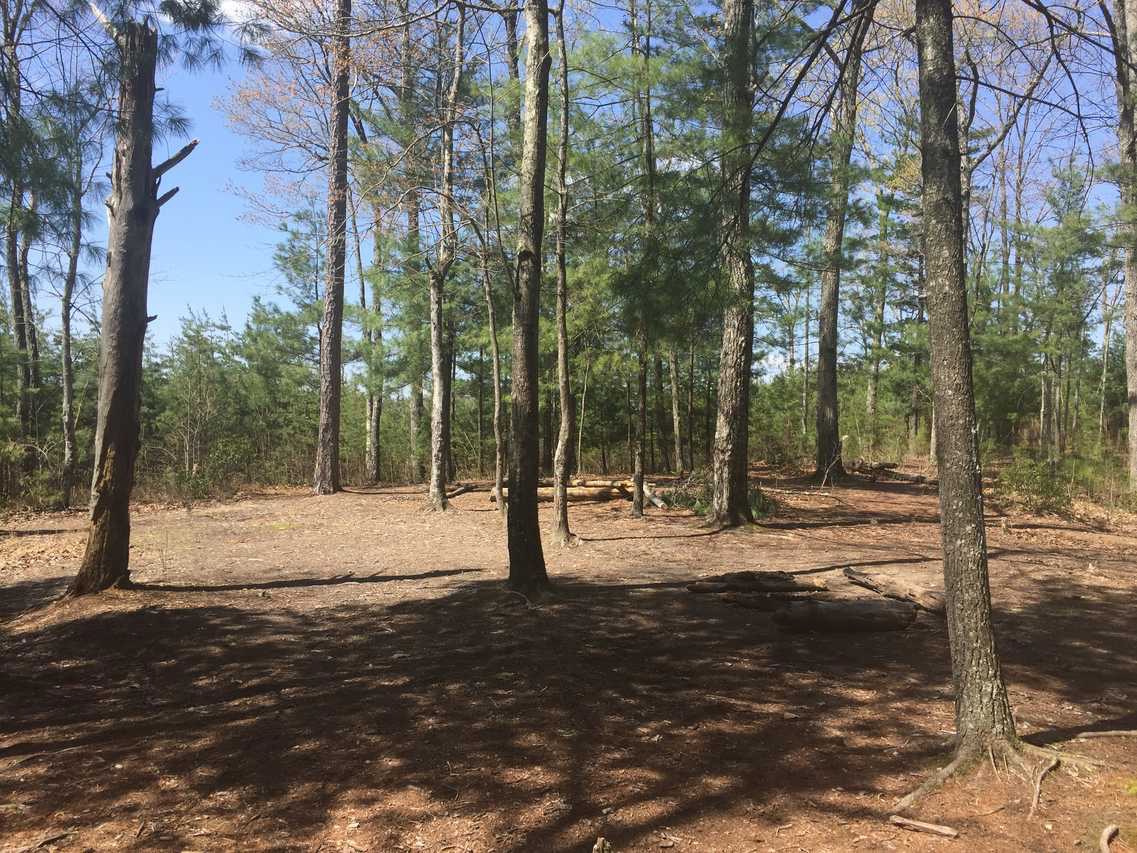 |
| photo of trail leaving Rough Trail for Hanson's Point and Pinchemtight. | To be clear, in the top photo, PinchEmTight Ridge is coming in from the left. There are a couple of trees blocking your view, but that's the Rock extending toward the Gap. On the right is Revenuer's Ridge. The southern wall of it forms the other half of PinchEmTight Gap. Revenuer's Ridge is very difficult to climb, with high cliffs all around, so early moonshiners built several stills up there. Their secret route to the top lies on the north east side, on the Rush Creek side. Due to underfunding and work backlog, the Forest Service has fallen behind on trail signage and maintenance. PinchEmTight Trail actually ends at the Rough Trail intersection. You turn left onto Rough Trail very briefly, then turn right on a faint trail heading into the bushes. If Rough Trail begins descending, you've gone too far. The trail winds through the bushes for a while. Eventually, you come to the big clearing (photo, above), which is Hanson's Point Campsite. From here on, there's not a single trail to the Rock but a series of them. Again, you'll think you've come too far, but just keep moving. The actual PinchEmTight Gap is down below. To get to it, follow Rough Trail down to Rush Creek, turn right (downstream) follow the trail north, and keep looking at the cliffs to your right. When you see a break in the cliffline, that's the Gap. Scramble up the bank and work your way along the cliffs to find the Gap. |
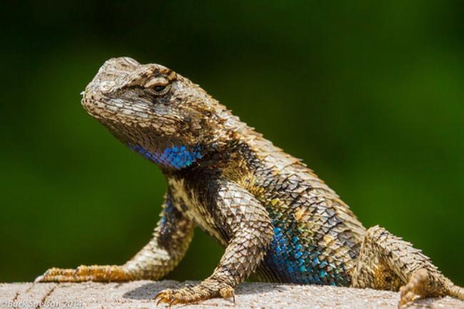
Skittering back and forth across the trail and large rocks and up and down the pine trees along PinchEmTight Ridge will be Fence Lizards (photo right) and Five Lined Skinks. Neither one is poisonous and they offer you no harm. Both live on insects, worms, spiders and other invertebrates. Local children often capture them and keep them in large terrariums or cages as pets, feeding them Crickets, Earthworms and Meal Worms bought at the local bait shops. They're both extremely quick, fast and agile and can be fun to watch. The Fence Lizard is cousin to the Texas Horned Toad. If you see one with blue coloring on the throat and belly, as seen here, it's a female. If you see one with greenish color on its throat and belly, it's a male. Fence Lizards average five year lifespans. They breed in early Spring and the females lay clutches of 5-15 eggs. A Fence Lizard can shift its color slightly to blend in with sand colored rocks, gray colored tree bark or dark colored soil, but they do it more slowly and don't have the range of their famous cousin the Chameleon. They don't have teeth but instead have sharp bony ridges. Snakes and Birds are their chief predators. They spend hours a day basking in the sun, turning their bodies perpendicular to its rays. |
 |
|
|||
|