Indian Staircase
| Route 66 | Cities | Beaches |
|
Indian Staircase |
|
| Auxier Ridge | Martins Fork | Grays Arch | Rush Creek | Pinchemtight | KoomerRidge | ChimneyTopCreek | ParchedCornCreek | SwiftCampCreek |
| IndianStaircase | Castle Arch | Osborne Bend | Raven Rock | Red Byrd Arch | Indian Creek | Revenuers Ridge | Copperas Falls |
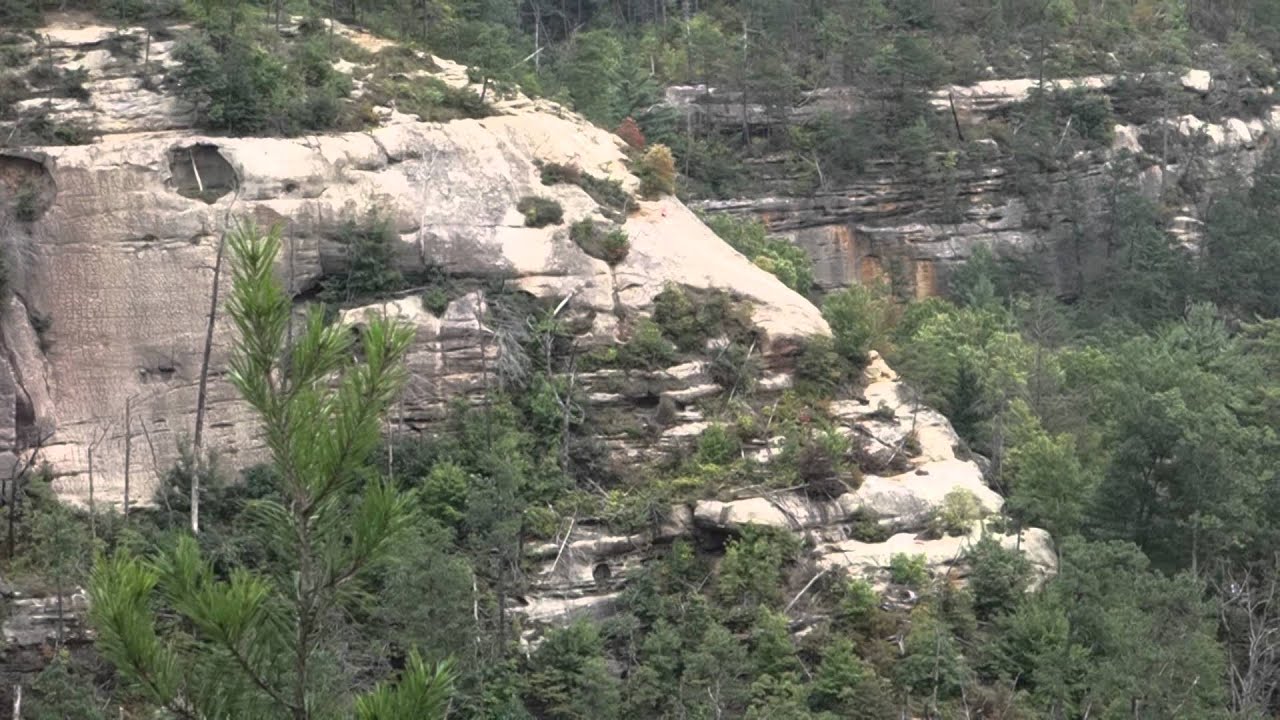
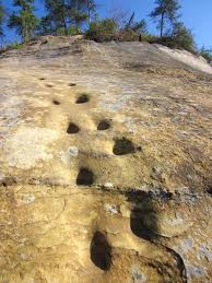
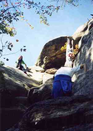
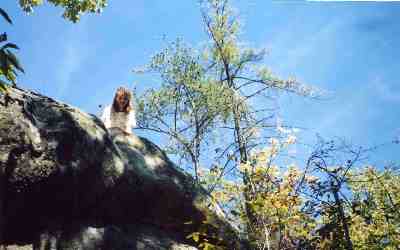
Indian Staircase is one of the more magical places in the Gorge. A thousand years ago, the Adena gouged foot and hand holds in what looks to be a huge rounded boulder face. Actually, it's a smooth granite cliff, somewhat out of place here in this land of sandstone, but it looks like a giant boulder somehow welded to the edge of a cliff. Anyway, anyone with basic body balance and rock climbing skill can easily work their way up the "boulder" to the plateau above, which offers scenic views in three directions and a photogenic forest plateau behind (shown below)). A group of grade school kids can climb the Staircase, but there are adults who cannot. Every year, many people get stuck about halfway up and have to be talked or helped down. Sturdy hiking or climbing shoes are needed. If you're bringing a group of kids with little climbing experience, a climbing rope might be prudent. One older guide can go on up, tie the rope to a tree on top, and throw the rope back down. Most people, however, won't need this assist. As can be seen in the photo top right, Indian Staircase is really a manageable 45 degree slope. But when you're at the base of it looking up, it seems much steeper. The foot and hold hands are also elusive. At the base, the "trail" disappears and you scramble up as best you can. Because of the curvature of the boulder, the foot and hand holds are not immediately visible from the base. Depending on where you begin your ascent, you may or may not find them. There's the major set, seen here at right, and a secondary set further over, which the girls in the photos are using. It is possible to climb without them, but it's easier with them, so you may find yourself sidestepping back and forth across the boulder in search. |
 |
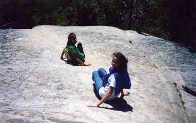 |
Before you begin this climb you might give some thought to getting back down. In the photo at left, the girls are basically scooting down on their butts. This strategy may horrify purists, but it works. Turning around and coming back down using the hand and footholds is also possible. But there are people who have a much harder time getting down than going up. They can't see where to put their feet when turned around facing the boulder surface, and they get dizzy looking down doing the butt scoot maneuver. If you get halfway down and freeze during the descent, you're going to be very difficult for others to help. So if heights bother you, or you've lost your flexibility, you might want to stay below in the nice cool shade and just watch your friends go up.
|
| The Forest Service apparently wants as few people as possible finding this place. There's no trail sign tjhat says "Indian Staircase" with a large arrow. On Route 715, just below the Gladie Creek Bridge, park at the Bison Way Trailhead, which includes a modern portapotty. From the parking lot, you can look down and see a nice level trail heading up Gladie Creek. If you have a topo map and some navigational skill, you can take that trail. It crisscrosses the creekbed up the valley, but you have to be able to cut off at Sargeant's Branch and follow it up to the Sheltowee Trace. There are no signs. If you're not confident in your ability to do this, then take the upper trail, which begins at the left corner of the parking lot. It heads up the hill. As you climb the hill, take the first right turn. Even though the main trail appears to head straight up the hill, the real main trail ("The Bison Way Spur") goes right. You will occasionally see signs labelled "210." | 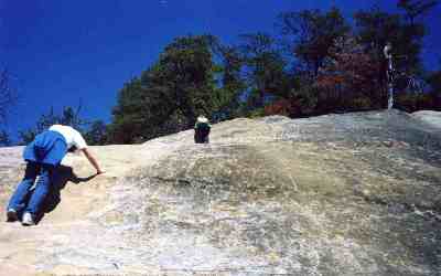 |
 |
The trail winds around the shoulder for half a mile, then drops steeply down to the very small Greasy Fork, crosses it, and climbs sharply back up to the Sheltowee Trace. This intersection is 3/4 of a mile in. Two signs clearly mark it. Turn left on the Sheltowee Trace. The sign points you five miles to the Swinging Bridge, although pedometers say it is seven. From the intersection, you'll climb slightly, level out, eventually cross Greasy Creek again, and come sharply back to your left. Begin looking here as you round another shoulder. The unmarked trail heading uphill to your right is Indian Staircase Trail. It's a pretty steep climb, but only for a quarter of a mile. Then you come to a cliff base and a very large cleft. You have to scramble up through this cleft, but there are numerous roots and angled rocks to grab. A recently fallen dead tree, still with its side branches, further complicates matters toward the top, but the cleft is not hard to get up. As you come back out into the sun, you're looking up at a chimney, that is, a squarish channel with a rock capping the top. This is climbable, and purists will insist on testing themselves. If you're trying to make life easy, like most hikers, you'll turn left, follow the rock base around 20 or 30 steps, and come to a low ledge you can scramble up to. You can then follow it back around to the top of the chimney, have an apple and wait for your companions to emerge at your feet. The photo at left is taken from inside the cleft, looking up at the cap on the chimney. These middle school girls are 13. But this introduction is a good test. You do have to be able to pull yourself up by your hands and arms. You have to be able to raise your front foot to about chest high, then hoist yourself up. If you don't have this strength in your hands and arms, and this kind of flexibility in your legs and knees, then you might not be able to climb Indian Staircase. |
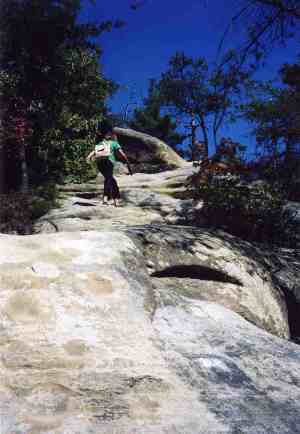
From here, you're looking straight up at Indian Staircase (right). It begins narrow and widens out. At first glance, the foot and hand holds may appear a little shallow, but that's an optical illusion. Once you start climbing you'll find they're fine. Local wisdom says not to look down while climbing, because you are getting pretty high and it can be disorienting. But we've had plenty of people look down and even take photos along the way, and they were fine. The biggest problem we've seen has been people trying to go up wearing thongs, Crocs, or other substandard shoes. Good climbing shoes that can grip are ideal. The next best choice would be a relatively new basketball shoe that still has its grip. Third would be a good hiking boot. Like everywhere else in the Gorge, Indian Staircase is a great place in the Spring and Fall but a brutal experience in the Summer, when the hot sun reflects back up from the whitish rock surface and the humidity makes you feel like you're being French Fried.
|
 |
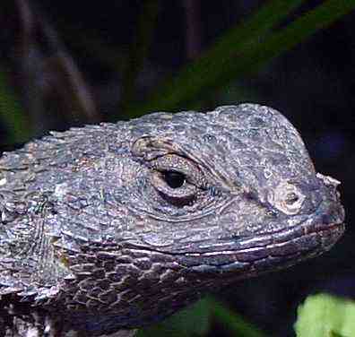 |
You need to brace yourself in advance about the Fence Lizards (left) which scamper back and forth across the boulder face. They can be startling, especially if they dart right in and look you in the face. But they don't bite and their claws are not big enough to hurt. You have to be able to keep your hand or foot in the hold even if the fence lizard pauses on the back of your hand for a look. Just keep reminding yourself that the fence lizard eats spiders, flies, centipedes and other crawling and flying critters and does not attack humans. If you happen to see a male during mating season, you're in for a treat. He sports a bright blue/purple patch along his throat and his body markings are brighter than usual. A fence lizard can be really beautiful. While you sit up on top and eat lunch, you might watch them. They're phototropic. They'll move around to position their bodies at right angles to the polarity of the sun's rays. They're one of Kentucky's underappreciated creatures, cousins to the Texas Horned Toad. |
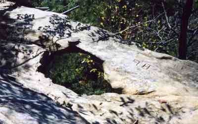
| Once on top, even if you came early and it's not yet lunchtime, you ought to sit and have a snack while enjoying the view. Notice over to the right (as you look back down on the Staircase), tiny Baby Arch (shown below left). Further out, you see two fingers extending southward, both tree covered but with sheer cliffs dropping down. You can use your topo map, navigate back through the Adena Plateau forest, and work your way to the tips of both those fingers. It is perfectly level and the forest is beautiful. You can also work your way around to the fourth finger, which you can't see, and have lunch on top of Cloudsplitter, looking down on the Gladie Creek Visitor Center. It'll take 30 to 45 minutes to navigate your way to Cloudsplitter without a trail. However, on the way, there's a passage which sneaks down the cliff to your left and comes to the largest rock shelter in the Gorge. Larger than a football field, it was used by the Adena for milennia. Archaeologists disagree on whether this shelter or the caves at the top of West Chimney Top were the largest Adena colony. | 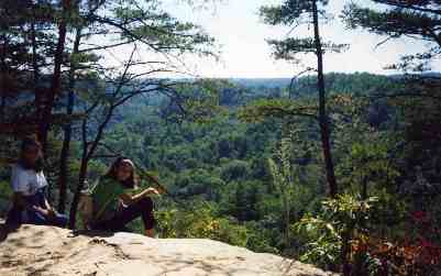 |
 |
If you want the experience on top but can't climb the stairs there's a bypass trail. It's not easy, either, because you're still climbing the same distance, but it's not a rockface. It's a real trail, well used, easy to follow. After you turn left on the Sheltowee Trace from Bison Way, look to your right for this trail in a Hemlock grove. You'll alternate dirt and sandstone as the trail pushes north and steeply uphill. The views begin to emerge as you climb above the trees. But the trail is very steep. You'll be pulling yourself up by roots and trees. You'll reach the top and enjoy incredible views, including Indian Staircase down to your right. Then you follow the trail around to the northwest. It will bring you to the top of Indian Staircase. Once again, going down will be tougher than coming up. You might study that tree - and - root section and decide whether to proceed. |
After descending, you might turn right on the Sheltowee Trace, hike up to the head of Sergeants Branch, turn the corner, and, as the trail begins climbing, look for the cutoff to your left. This takes you to Indian Arch and Adena Arch, two of the least visited natural arches in the Gorge. Adena Arch is a lighthouse arch, meaning the hole has occurred fairly recently, and is still small. If you want to finish out the day with a long hike, just keep going on the Sheltowee Trace, and you'll come to Route 715 and the Swinging Bridge. But it will be another several miles back up the road to the Bison Way Trailhead, so if you're going to do this you need to plan ahead and park another vehicle over there. Above left is Baby Arch, and at right is a climber looking back down into The Chimney.
|
 |
|
|||
|