| Route 66 | Cities | Beaches |
|
|
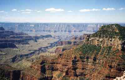
Everybody needs to backpack The Grand Canyon. The place is just amazing. We live in this age where every thing is so overhyped the reality is always a disappointment. Not The Canyon. People can't overhype it because they can't capture it. Not in words or on film. We'd all seen hundreds of photos and paintings and watched several movies of it, and when we got there it just sucked our breath away. We had experiences there we'll never have until we return. We started by hiking the South Rim Trail, an all day adventure of its own that ranks as one of the world's top 10 day trips. We urge everyone to begin your visit by doing this. You need time to adjust to the altitude, heat, light, dryness, and general weirdness.We looked down on the top of thunderstorms, standing there in bright sunlight watching lightning flashing out from below black clouds way below us. We saw planes flying way down there, looking like little toys, too far away to be heard. |
 |
 |
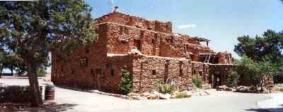
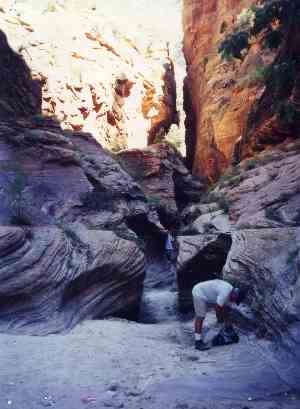
Stopping for water breaks and lunch, we realized places keep changing, shifting, all day, every few minutes. As the sun moves across the sky, it reflects not only off a spot, but off a hundred other spots that themselves affect the light on that first spot. So every 15 minutes, the colors, shadows and whole appearance of each spot totally changes. The Canyon is thus like a disco ball. You can set up a camera aimed at a particular scene and shoot a whole roll of film, a new picture every 15 minutes all day, and no two pictures will be alike. Pinks, purples, reds, yellows and blues keep interacting with each other. Far below us, we could see the South Kaibab Trail, just a dusty brown line, as shown at left. Eventually, we found other trails, some descending to the river, some, like the Tonto Trail, running along the plateaus. The trails appeared to be empty. Then we used our binoculars and could see they were teeming with people backpacking and others riding the donkey trains. The trails are so far down you can't make out the people or donkeys with the naked eye. We had the same experience with the Colorado River. At first, all we could see was a tiny brownish green line, way out there, squiqqling westward. Then, with our binoculars we could see how big and powerful the river is, and could make out the rafts loaded with people descending the canyon on one of the commercial trips. The Colorado is moving so fast it's dangerous to hikers and campers, who could be swept away trying to wash dishes or cool off their feet. The rapids and waterfalls are so big the rafts have to be large to carry passengers safely without being swamped. Yet even with that fast flowing river and those big rafts, a trip through the canyon takes a full week. On your day or so of orientation on the South Rim, be sure to take advantage of the great restaurants and gift shops. You do have to make reservations by about noon to guarantee seating for dinner, but it is definitely worth it. Drop in on the old lodges, especially El Tovar, even if you're not staying there. They're century old examples of that National Park Rustic architecture and are national treasures. There are bus tours and ranger presentations. If you come in by van or car, check the schedule and make sure you drop by the railroad station to see either the arrival or departure of the daily passenger train. This is a historic gem in its own right, all original, beautifully maintained, worth several photos. Do not be deceived by the desert climate and Arizona location. Summer nights here can get cold. We've slept in hooded sweatshirts in down bags in June on the South Rim, and the North Rim is even colder. However, down in the Canyon nights are much warmer. |
| So where do you start? We seriously urge you to make The Grand Canyon an Amtrak trip. This is one of the three greatest Amtrak trips in America (along with Glacier and Cascades). And your vehicle is a liability here. On our last trip, we could still bring the van into the park, but the traffic was gridlocked and there was no place to park. They are in the process of outlawing vehicles in the park; you'll have to park at the entrance and take an electric tram in. So just come in by train. Have someone drive you to the nearest Amtrak station, spend two days on the train, and step off at the edge of The Canyon. Actually, it's more complicated. You'll get off Amtrak at Williams, Az.,and spend the night. | 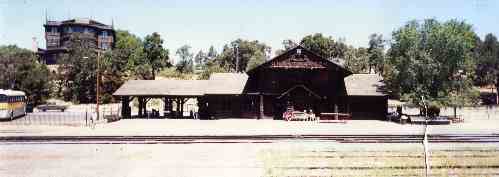 |
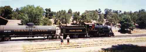 |
Then you'll board The Grand Canyon Railroad for the last leg of your trip. But this is wonderful, because you'll be riding an authentic 1800s steam train with the original passenger cars, on the original trackbed right down to the original bridges and trestles, coming in to the original station. Get sleeper compartments on Amtrak, enjoy eating three meals a day in the diner, then go upstairs in the observation car and watch the American West drift by out the big picture window. It's a vacation all by itself. For most kids, this will be the only train trip they'll ever take. |
|
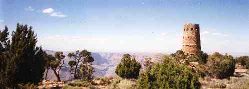
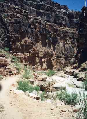
However you get to The Canyon, we recommend coming in at the South Rim and camping for two nights. There are lots of things to see and do here, and since you're not likely to make it back for a while, you want to take advantage of the opportunities while you can. That first full day, you want to hike the South Rim Trail all the way out to Hermit's Rest, spend a while there, then take the shuttle back. Go in the various hotels, browse in the gift shops, and stop at the visitor center. Take the Desert View Shuttle out to The Old Navajo Tower (shown lower right). A Canyon trip requires the most advance planning of any national park trip. You will want to read this material, do your own research, sign up those who are going and collect advance payments, then apply the previous summer for Amtrak, Grand Canyon Railroad, camping, trail, Phantom Ranch, North Rim cabin, mule train, rafting, or any other amenities. All this for early June. If you want a July or August trip, two years advance reservation will be needed. |
|
 |
 |
 |
 |
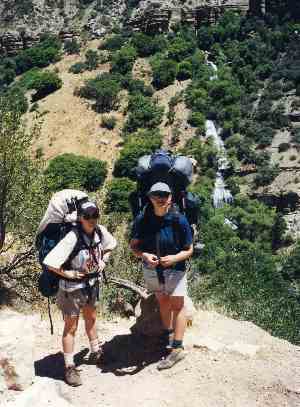
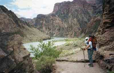
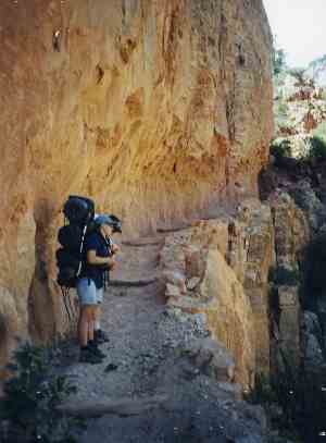
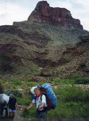
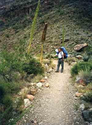
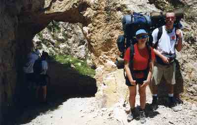
We prefer going down the South Kaibab Trail and making the descent to Phantom Ranch in one day. The descent is long and hot, so be in shape, carry more water than you think you could possibly need, and plan on stopping often. Remember it isn't just downhill. It's very steep downhill on sand and rock. It is more difficult going downhill here than coming up. Your knees and the back of your calves will feel the last two miles. And there are no railings or trees to grab. We highly recommend trekking poles. At the very last minute before leaving the top, soak two bandannas in cold water, do not wring them out, and tie one around your head and one around your neck. Wear a broad brimmed hat and wrap around sunglasses, coat yourself liberally with sunBLOCK, and carry an extra sunblock bottle. This is serious business. They rescue people here every day. You will probably be stopped and checked by a ranger as you begin the hike to see if you're following all this advice. They routinely turn people back who do not have the necessary water, sunblock, hat and glasses. Once past that, they ask about health problems and caution them about various dangers. |
To get to the South Kaibab Trailhead, just keep walking east along the South Rim Trail, past the Visitor Center, Yavapai Point and Mather Point. Yaki Point is where the trail heads down. The campground is just above the Visitor Center, so you can walk straight over along the road if you camp there as we recommend. Your hike begins innocently enough, as you walk out the top of O'Neil Butte, dropping only gradually until you reach the end of the rock finger. Then you drop steeply down and curl below Natural Arch. Here, you level out briefly on the Tonto Plateau, a one hundred mile long narrow shelf. You'll cross the Tonto Trail, a major Canyon throughway which follows the length of the Plateau and serves as an east - west connector between a dozen other trails running from the rim down to the river. On a future trip you can plan trips along the Tonto Trail, which leads away from the crowds and into some of the most remote and spectacular areas of the Canyon. But except for Indian Gardens, there's no water on the shelf. On a first trip, you need to stay on the more popular trails, where water is available occasionally. |
 |
 |
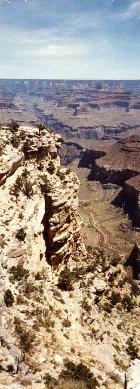
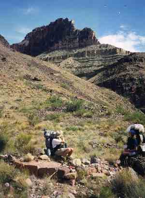
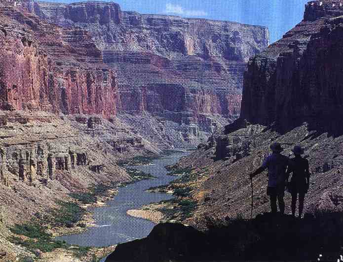
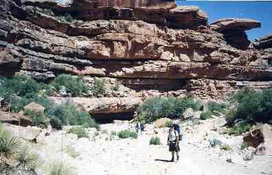
Shortly after crossing the Tonto Trail you reach The Tipoff, a rock formation which signifies your hairy descent off the Plateau down to the Colorado River. If you're at this point by 1 or 2 pm you're fine. You will get some of your most stunning photos along this section, but you need to watch your footing. People have taken some nasty falls gawking at rock formations while the trail dropped away below them. You'll be switchbacking your way down a couple of thousand feet. The Canyon walls, pinnacles and towers are now beginning to tower above you in all directions. But eventually you'll come out at the gauging station which tracks river depth, speed and volume. You will then hike about half a mile along the river to the famous swinging bridge. It's a pretty entertaining walk. You will actually find a little shade, something you haven't seen all day. You'll see white water rafters maneuvering through the rapids, especially right above the bridge. And it's a great feeling to know you're close to Phantom Ranch and a good dinner. |
|
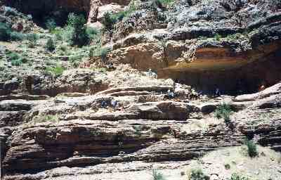
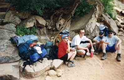
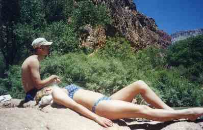
The Phantom Ranch experience is central to a Grand Canyon trip. You can camp along Bright Angel Creek or stay in one of the bunkhouses. There are no showers, but there are modern bathrooms, complete with sinks and mirrors. However, the creek runs cool right past the camp and you can sit in it for relief from the 100 degree heat. And you can eat dinner and breakfast in that incredible mess hall. There's no menu. You eat what they set in front of you, just like cowboys do at any ranch. But you certainly won't have any complaints, about quality or quantity. Phantom Ranch is a world unto itself. You can spend a day sitting on the benches watching the backpackers, mule trains and white water rafters arriving and departing. After dark you can look out your tent or from the bunkhouse door and watch the scorpions glowing in the dark as they hunt for food. There's a first aid station for backpackers with blisters, heat prostration or scorpion stings (they treat them with milk). And there's even a pay phone, since your cell phone probably won't work. |
 |
 |
If you can stay at The Ranch an extra day, there is an outstanding side hike up Clear Creek Trail through Zoroaster Canyon to the Ottoman Amphitheatre. You get great photographic angles of Thor Temple, Zoroaster Temple, Bradley Point, Demaray Point and Howland Butte.These are just names on a map until you get out there and see them, but then they become awesome landmarks worth a day. |
 |
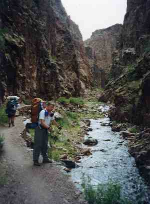
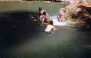
There are also bushwacking routes you can try for an hour or so which lead to awesome scenery. A great route is Phantom Creek (photo at right), which leads westward out of The Box. It winds below the Cheops Pyramid, Sturdevant Point, Isis Temple and Schelbach Butte. This could be a major adventure if you wanted to follow the creek all the way to the rim, but the last mile is hairy scrambling. Another route is to hike back down to the Colorado and follow the trail upstream to the north side Gauging Station, then scramble up rock and sand until you reach the overlook shown at left. | 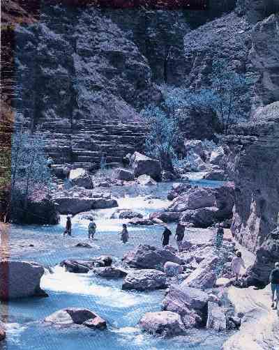 |
 |
After one night or two, however, it's time to pack up, eat breakfast and head North. You want an early start, because you're going through The Box, that famous microwave where by 11 a.m. you could find yourself in 120 degrees. The terrain on this day's hike is a very gradual climb, and you'll be following Bright Angel Creek, so you can wet your bandanna as often as you like. The rock formations around you are magnificent and the plant life is exotic, with yucca, cacti, and other desert plants, many of them in full summer flower. You just have to deal with the oppressive dry heat. As you approach Ribbon Falls the trail begins climbing, so you finish the day with about 30 minutes of steep uphill. But that brings you to Cottonwood Camp, which has fresh water and beautiful Ribbon Falls, worth the short walk and a few photos. If you can wake up in time for sunrise next morning, you can take some incredible pictures of the Buddha Temple catching the first rays. |
 |
 |
The climb up to the North Rim is an epic adventure. You need to leave early, carry plenty of water, stop often, and keep cameras ready. The trip begins with a two mile, reasonably climbing, fairly straight stretch following Bright Angel Creek. The scenery grows ever more awesome as you climb above buttes and spires and can see out across vast expanses of The Canyon. You come to a pleasant little oasis at Roaring Springs, where Bright Angel Creek forks. An old house, grove of shade trees, safe water, and wall to sit on offer a late morning break. But our recommended route follows the left fork up Roaring Springs Canyon, and from the time you leave the oasis until you reach the North Rim Trailhead, the trail is relentlessly steep with continuing switchbacks. Sometimes you're deep under the cliffs in shade, sometimes you're way out on points or promontories in blinding sun. Waterfalls gush out of cliffsides and tumble hundreds of feet downward. Snakes and lizards sun themselves on flat rocks. |
 |
About once an hour, a pack train heading up or down passes you. The rule is that they have the right of way. You are to step above the trail and remain motionless as they pass. In many places this is easy, but if you meet one where the trail narrows against the cliff it becomes pretty dicey. You lean back into the cliff, but of course your pack prevents you from getting totally out of the way. The animals seem to be dangerously close to the edge. Fortunately, they've been carefully trained, most of them have been doing it a long time, and they're extremely sure footed, so they manage to skirt the edge without incident. There are only a few places where the wrangler will hold the train until hikers clear the section. Back in Kentucky, the present fad is the internal frame backpack. Sometimes we go whole weekends and never see anyone with an external frame pack except us. And some of us have even used internals out West in places like the Wind Rivers, Yellowstone and Glacier. But not in The Canyon. We didn't see anyone with an internal frame. They would be too hot. The external frame allows air to circulate between the back and the pack. Kelty Tiogas and Super Tiogas for guys and Gregory Evolutions for girls seem to be the overwhelming favorite of canyoneers. |
| In some places, the trail narrows until you're hugging the cliff wall, as you can see in the middle background of this photo. Then it widens out again under the rock shelters, again as seen here. The odd looking hat is a French Foreign Legion item which can be soaked in water. Evaporation provides a little cooling effect. In 120 degrees every edge helps. At the location shown, we're almost directly beneath the Grand Canyon Lodge, perched at cliff's edge two thousand feet up. From the oasis to the trailhead we are climbing 3600 feet in 4.7 miles in searing heat and zero humidity. It's hard to believe that in midwinter this trail becomes impassable in deep snow and ice. Thankfully, the last segment of the trail is in forest, as you top out on the North Rim. You're still climbing and switchbacking steadily, but you're doing it on soft loam, in shade, with even the hint of a breeze occasionally. If someone is meeting you with a vehicle, they'll be parked in the lot at the trailhead. Otherwise we suggest turning left at the water tanks and walking to the campground. | 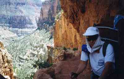 |
 |
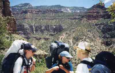
We recommend spending at least one full day on the North Rim, but ideally you could stretch this to two or three. It's worth it. There are more hiking trails on this side of the park, more wildlife, and more variety. The climate is cooler, you're in forest almost all the time, and there are only 10% of the people. This is really the outdoors part of the park. The Canadian Conifer Forest Zone is home to quite a few black bear, wildcat and mule deer, and reclusive mountain lion and wolves. The campground here is beautiful and the lodge magnificent. But if you can splurge twice on your trip, we urge you to rent one of the cabins and eat one dinner in the dining hall. The day hiking here is some of the best in any national park. If you hike over like we did, we recommend the Ken Patrick Trail to Point Imperial and Kolb Natural Bridge, including the Uncle Jim Sideloop which will give you stunning views down that Roaring Fork Gorge you labored up for one whole day. We also recommend the Widforss Trail, from which you can look down on the Phantom Creek drainage coming up from the ranch. |
We don't usually like to retrace our steps, much preferring loop hikes to out and backs. So we did not look forward to hiking back down the 16 mile North Kaibab Trail. However, we were really surprised. It was a whole new experience. Part of it was that we had struggled up the long grade and on the return we could relax. Part of it was that we were facing out across The Canyon so the view was incredible. And part of it was the morning sun on the top half of the route, rather than the afternoon sun and deepening shade we had seen coming up. Altogether, we really enjoyed the return to Phantom Ranch. Whether or not the mule trains will still be operating on this side of the park when you make your trip is uncertain. They're a century old tradition, but lately park officials have considered terminating the North Rim service and limiting mule trains to the South Rim. They believe the mules' heels damage the trailbed, their grazing impacts the ecosystem, and their waste degrades Bright Angel Creek. |
 |
 |
You might be tempted to make this a one day marathon. Don't. The Grand Canyon should be savored, not raced through. We met people who were hurrying. Some of them made the rim to river trip in one day. Others actually ran from rim to rim in one day. These people were using daypacks and staying and eating at the lodges or the ranch. But we watched these people, and talked to them at dinner. They didn't seem to us to be having much fun. Most of them were from California or somewhere in the Southwest within a day's drive of The Canyon, so they could come here several times a year. At other times, they would backpack it for a week, just as we were doing. These marathons they hiked or ran were more of a fitness challenge than a Canyon visit. We don't see much value in hurrying the experience. |
This is a pretty demanding trip, and should absolutely not be the first expedition a youth group or family makes. You need some prior experience in hot weather parks like Bryce, Zion and Big Bend and long backpacking treks like the Wind Rivers and Glacier.You also need time to accumulate the needed equipment and learn how to travel as light as possible and still have what you need. We never carry more than 30 pounds per person into the Canyon. Of course, knowing you can eat meals at Phantom Ranch and North Rim Lodge lightens your load somewhat. You only need to cook at Cottonwood both directions and Indian Gardens on the return trip. This reduces the amount of food and fuel you need. You won't need the cold weather clothing and down bag unless you plan to camp on the North Rim. Use them on the South Rim, then leave them in your van or check them in a pay locker when you hit the trail. Conditioning is another issue. You have to invest some time in conditioning before this trip. In Kentucky, hiking the Gorge, big South Fork and Cumberland Gap can tone your legs and cardiovascular system for the long, steep climbs and descents. If you live elsewhere, find a trail in your state with challenging ups and downs. Or find a college football stadium and, wearing your loaded backpack, hike to the top and back down several times, and do it three times a week for a few months. In the gym, we like a good stepper, a treadmill that can be cranked up to at least a 20% angle, a leg press machine, and an abflexor. Remember to turn around on the treadmill and do at least a mile a day backward, to condition shins, calves and thighs for the long descents. |
 |
For a bunch of kids from Kentucky, The Canyon's small animals are a continuing source of fascination. The glow in the dark scorpions, their tails poised over their heads, are pretty hard to match. But the long tailed pocket mice, red spotted toads, yellow backed spiny lizards, banded geckos, and collared lizards are pretty unique, too. Ring tailed cats and gila monsters scared several of us at one time or another. And the hump backed chub, the world's largest minnow, which lives on birds and small mammals that fly too low over the water or wade out in it for a drink, was pretty wierd. We also enjoyed talking to the people who live in The Canyon. They worked at ranger stations at Roaring Springs and Cotton-wood Campground, wrangled the mule trains making one trip a day from the rim down to the ranch, guided the rafting trips, or staffed the first aid station or mess hall down at the ranch. Many were college graduates now in the park service. |
 |
 |
The photo to the left is what you'll see looking out your tent doorway if you face it west at the Cottonwood Campground. It surely has to be one of the most spectacular campgrounds in the national park system. And there's a surprising amount of water nearby. Bright Angel Creek runs past it, foaming and splashing. Ribbon Falls continually roars from across the creek. Several other smaller waterfalls erupt out of the cliffs in every direction. And just down the trail, there is actually a bog where you have to balance on logs and rocks to keep your feet dry for a quarter of a mile. You could spend a couple of days here at Cottonwood. Just trying to capture the place on film would take a whole day. Studying all the bizarre plant life could take a morning. Watching various kinds of lizards is worth at least an afternoon. And then there's the geology. The Canyon is a whole geology course in itself. We learned more about geology, and learned to appreciate it more, in our week here than we have in all our Earth Science courses combined. A lot of us were already interested in ecology, or became interested through all these outdoor trips. So we enjoyed sitting around the campfire and listening to the ranger tell us about the "islands in the sky" ecologies of these rock formations. Jutting up as they do, they provide level islands for various plants and animals. But because of the incredible elevation differences, which are accompanied by temperature and water differences, many of those plants and animals cannot move from one island to another, or from an island to either of the rims. So they've been stranded there for thousands of years, and have begun evolving slightly different characteristics. |
If you wanted to make this trip but were afraid of the rugged backpacking challenge, you could compromise and ride the mule trains down and back, then day hike out from Phantom Ranch. The mules take one day each way, with a few stops to stretch your legs. Even this alternative is no easy cruise. You'll still have the heat and the sun to contend with, and because of the steep trails and frequent sharp turns, your butt will take quite a pounding. As with the backpacking trip, the climb out is easier than the descent. With the mules, you'll face another hazard. Although the animals are quite safe and sure footed, there is the illusion of danger. From your high perch, it will seem like you and your mule are about to plunge off the cliff. We've known people who kept their eyes closed except for the plateau crossings. The feeling of imminent disaster is especially acute when you pass hikers on narrow trails. The mules are fine, but you may be panicky. It helps to remember that mules have been making this trip for a century and none of them have been lost over the edge. Mules are much more surefooted than horses. If you want to try this alternative, be sure to make your reservation 12 months in advance. You need not only the mule train reservation down and back, but the overnight accomodations and meal reservations at Phantom Ranch. Then figure on the day hikes out from the ranch. Bring your daypack. Taking the mule train down one day, staying four nights and three days at the ranch, and taking the mules back up on the fifth day, makes for a good trip. |
 |
 |
We highly recommend ordering a few books on the plants of the Canyon and studying them for several months before coming. The place is a botanical fireworks display, but you appreciate it more if you know what you're seeing and can look updetails along the trail. The cacti are especially fascinating. So are the little oases where springs gush out of the cliffs, or strips of lush grass and trees where streams flow down. The study of ecology is magnified here, since you rapidly descend through different zones between the rims and the river. The way plants here use their leaves, stems, roots and flowers to survive in such hostile conditions is a whole semester course at Northern Arizona University over in Flagstaff.
|
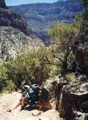
As you notice from the pack covers in the pictures above, we got rained on coming down from Cottonwood Campground to the ranch. It was strange. The water was steaming where it hit the hot rocks. But it was sort of refreshing, and it cooled things off briefly. The Box was a lot more enjoyable without the intense heat. As you relax at the ranch one more night, you have decisions to make. First of all, we recommend turning right across the bridge and heading West. This will send you up the Vishnu Switchback, an awesome climb to the Tonto Plateau. The campsite up there is Indian Gardens, where the Havasupai actually did raise crops. There is a ranger station, composting rest room, water and even a little shade. You then hike out by heading straight up Bright Angel Trail. It's 4.7 miles to the top, with resthouses at the 3.0 and 1.5 mile points. After the rugged semiwilderness you've been through, this is a real luxury. But this is a steep climb, and will take most of a day with a backpack. |
 |
 |
Left, at the first rest house, part of our group pauses. Steps at the left lead up to water and restrooms. Right, the tunnel at the top, just before you come out at the parking lot. Just past this tunnel, a ranger usually checks those starting down for water and permits. However, if you have time, energy and freeze dried food and want a grand finale to your Canyon adventure, we suggest you head West from Indian Gardens on the Tonto Trail. You'll need to carry plenty of water, but the hiking will be level and the trail smooth |
 |
 |
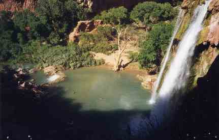
Eventually, take the South Bass Trail up to the rim, where it becomes the Esplanade Route. Follow it to Apache Point. The trail ends here, but you're on top, and it's an easy orienteering cross to Topocoba Hilltop, where the trail begins again, now known as Topocoba Trail. Follow it down to Havasu Springs, where you join the Hualapai Trail and continue downstream to the village of Supai. After checking in at the Visitor Center, you hike another mile below the village to the campground. And you have found the closest place to Shangri-La available in the U.S. The pictures left and below show why. Beautiful waterfalls and pools are bordered by smooth rocks and oak trees. A spacious shady campground along a deep, cool, rippling stream. A spring bubbling out of the side of a cliff. This is Havasu, the Grand Canyon West, a part of the park seen by less than one per cent of all visitors. Making this visit will take a little advance planning, however. For this is Havasu Nation, the Indian Reservation. You need to apply for passports and wear them on your backpacks. You need advance reservations at the campground. |
There is a small hotel in the village, and if you want to end your trip in luxury you could come out by horse train. But both these options require advance reservations. From your campsite, you can hike down to the Colorado River, a two hour jaunt that will pass two more gigantic waterfalls and a set of iron rungs sunk into the side of a cliff. There is a restaurant and snack bar in the village but the menu is disappointing. It's more like a fast food outlet back home. Jewelry makers on the village square offer incredible buys on silver, jade, and turquoise earrings, necklaces and bolos. |
 |
 |
This is a window back in time. There is no road, no electricity, no phone, no tv. Your cell phone is out of range. You can watch the mail and supplies come in daily by pony express. Residents farm, hunt, fish, raise horses and dogs, lead pack trains and rafting trips, make things to sell to tourists, or work at the store, restaurant, hotel or government agency. There is a K-12 school. Basketball is the official team sport. The kids heard some Kentuckians were at the campground so they looked us up and wanted a game. Our guys met them at the outdoor court (there is no gym) and played until dark. The Havasupai were pretty good, although some of our guys were on the school team and we won the best of three series. Running Bear, our campground host, sat around the campfire one night and spent two hours teaching us about Havasu life. The hostess at the visitor center, Raven Wing, was a University of Arizona graduate. |
|
Our guys thought the Havasu girls were sort of cute, but the adult women were all overweight and looked exhausted and sullen. We never heard one of the women speak the three days we were there. The hike out is just as steep as the Roaring Springs or Bright Angel Trails. The picture at right shows the convoluted canyon you come through. This photo looks like some sort of lines are cutting across it, but they're not. That's just the way the rock layers line up. You could exit the canyon by two routes. You can go back the same way you came in. Or you could have someone bring your bus or van around to Peach Springs and either hike up or take the pack train up to the trailhead, which is called Hualapai Hilltop. If you came by Amtrak, you'll probably be better off going back the way you came, so you end up at the Grand Canyon Railroad Station. If you wanted to tack the Havasu experience onto the end of your Grand Canyon trip but had a very young group and didn't think they were up for the necessary hiking distance in the heat, there is a roundabout way to do it. You could hike out Bright Angel Trail as described, drive your van or bus out to Williams, head west on the interstate to Peach Springs, and take the side road in to Hualapai Hilltop. You could camp there for the night, then hike four hours down to Supai and the campground. Returning to your vehicle after a day or two, you can catch the interstate at Peach Springs and follow it east through Flagstaff, Albuquerque and home. A park service shuttle van also makes this run. |
 |
|
|||
|